
The unfolding tragedy of the current wildfires across Los Angeles County which has killed at least 24 people, and destroyed or damaged over 12,000 structures, reminds us of the overall dramatic increase in the frequency and intensity of wildfires across the U.S. and Canada over recent years, and just how the multi-faceted nature of wildfire risk has created a complex and dynamic risk landscape needing the insurance industry to re-evaluate wildfire as a primary peril.
The overall surge in wildfires in the U.S. can be attributed to several key factors – of which many are in play with the Los Angeles County wildfires. Climate change is an important factor – it has altered atmospheric patterns and led to more erratic and extreme weather events which can result in wetter ‘wet’ periods (increasing vegetation growth) and drier ‘dry’ periods exacerbating prolonged droughts (drying out vegetation).
For instance, examining rain gauge data at Los Angeles International Airport, the season (defined as July 1 – June 30) in 2022-23, and 2023-24, saw rainfall totals almost double the season average of 12 inches.
So far this season, by the end of December 2024, the rain gauge at LAX has totaled just 0.03 inches, already more than three-and-a-half inches behind the average at this time of the year, two months into southern California’s ‘wet season’ between November and April.
This volatility, swinging from excessive rain to excessive drought, increases the complexity of wildfire risk and in certain cases creates more favorable conditions, such as for fuel to develop and wildfires to spread more easily. A late dry spell such as this year can make vegetation even drier than in a ‘normal’ season where some rainfall would have already fallen.
Additionally, population shifts in risk-prone areas and proximity to the wildland-urban interface (WUI), exacerbate the risk. As more people move into these areas, the potential for ignition incidents (90 percent of ignitions are by human activity) from various sources and the exposure of homes and infrastructure to wildfires also increase.
For Los Angeles County, the greater metropolitan area is surrounded by the Angeles National Forest to the north, and the Santa Monica Mountains to the west, as urban expansion into the WUI creates a complex dynamic, making wildfire management and fire extinction more challenging with more people and properties are exposed to potential fire damage.
Los Angeles County has around 346,000 acres of WUI from a total of 2.61 million acres. For California overall in 2010, the number of houses within the WUI had grown to 4.46 million, and the population had grown to 11.2 million, making it the state with the largest number of houses and population in the WUI.
With strong ‘Santa Ana’ winds blowing from the mountains to the Pacific, and at times peaking at 100 miles per hour in Los Angeles, the ember spread can radiate for miles, and we have already seen images of neighborhoods impacted by urban conflagration where the structures are destroyed, but some trees still stand.
Winds not only drive the spread of the fire but make containment very difficult, vital tankers of water dropped from the sky are either grounded by the high winds or the water is dispersed by the wind away from its intended target.
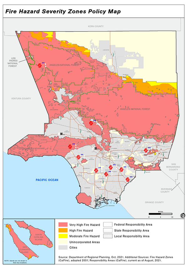
Figure 1: Fire Hazard Severity Zones Policy Map. Source: Los Angeles County Department of Regional Planning
Because these factors are so multifaceted, their compounding effects are exacerbated. No single factor is solely responsible, but when combined with the right conditions, they can lead to more extreme events. Understanding these interconnections is crucial for developing effective risk management strategies that account for the cascading effects of different perils.
The Role of Antecedent Conditions
Antecedent conditions, such as heavy rainfall from storms and atmospheric rivers, can increase vegetation growth, which then becomes fuel for wildfires during dry periods. This concept of ‘long-term memory’ in wildfire behavior suggests that past weather events and climate patterns may influence future fire seasons.
For instance, heavy precipitation from atmospheric river events in California – seen in 2018 and 2023, and other regions, can increase soil moisture which spurs vegetation growth to produce a temporary effect of inhibiting fires. However, once the region enters a prolonged drought cycle and vegetation dries out, it becomes fuel that is more conducive for fires to spread, resulting in potentially more extreme wildfires.
Extreme storms are another important factor, for example, Tropical Storm Hilary in 2023, the first tropical storm in California since 1939, brought significant rainfall to Southern California, and led to increased vegetation growth. It was followed by the subsequent drought in 2024 that created favorable conditions for wildfires, with the increased vegetation from the storm serving as fuel.
While it's important not to draw direct conclusions, these events highlight the complex interplay between antecedent conditions and wildfire risk. Additionally, phenomena such as La Niña and El Niño significantly influence weather patterns, including rainfall and temperature, which affect wildfire risks. These factors are important to examine and understand as we seek to better predict and manage future wildfire events.
Moody’s RMS U.S. Wildfire Models Enhance Wildfire Risk Management and Build Resilience
Our latest wildfire risk model, Moody’s RMS U.S. Wildfire HD Version 2.0 models the continuous stochastic ‘fire weather’ to fully capture the temporal (e.g., antecedent conditions and clustering of events) and spatial correlation of all sources of wildfire risk.
This model provides a more robust and comprehensive view of wildfire risks and enables stakeholders to manage and mitigate risks effectively. Our model plays a crucial role in understanding and managing wildfire risks, to provide a more accurate depiction of current wildfire risks by incorporating climate change into the data, the latest fuel load/availability, ENSO indices, as well as the impacts of droughts. These significant advancements in wildfire risk assessment offer detailed insights into property-level mitigations and supporting community risk reduction strategies.
Moody’s RMS models can help build a more resilient future and adopt adaptive strategies, such as using vegetation management and fuel reduction practices, as collaboration between stakeholders is another crucial element when developing effective wildfire prevention and response strategies.
Our models can help stakeholders better understand and manage the complexities of evolving wildfire risks, with the insurance industry, policymakers, and communities also having an opportunity to navigate the complexities of today's risk landscape and ensure better coverage and protection for those affected by natural disasters.
Follow Moody’s – Insurance Solutions on LinkedIn and also monitor the live blog for new posts.
learn more
Climate risk for insurers
Moody’s climate risk solutions empower insurance providers, brokers and reinsurers to assess interconnected physical and transition risk across the life, property and casualty markets.